Camping Les Murets is located along ‘Le Grand Site de la Boucle de l’Ourthe‘, a protected nature reserve in the beautiful Condroz region, the gateway to the Ardennes. From the campsite it is therefore immediately beautiful hiking.
Hiking map close to Camping Les Murets, Esneux
The nature reserve is crossed by several signposted hiking trails: ![]() Via Mosana, part of the pilgrimage route to Santiago de Compostela,
Via Mosana, part of the pilgrimage route to Santiago de Compostela, ![]() GR57, a long-distance walk, and the
GR57, a long-distance walk, and the ![]()
![]()
![]() routes from the local TARPAN network Esneux-Anthisnes. Below you will find flyers of the TARPAN routes.
routes from the local TARPAN network Esneux-Anthisnes. Below you will find flyers of the TARPAN routes.

The RAVeL de l’Ourthe, which follows the river, also passes our campsite. The campsite lies between nodes 22 & 23 of the network Node System of the province of Liège, which is based on the RAVeL among others.
RAVeL routes are mostly flat cycling and walking paths where for the most part no cars come. RAVeL is short for ‘Réseau Autonome de Voies Lentes’, ‘autonomous network for slow traffic’. They are the old towpaths along rivers or disused railway lines.
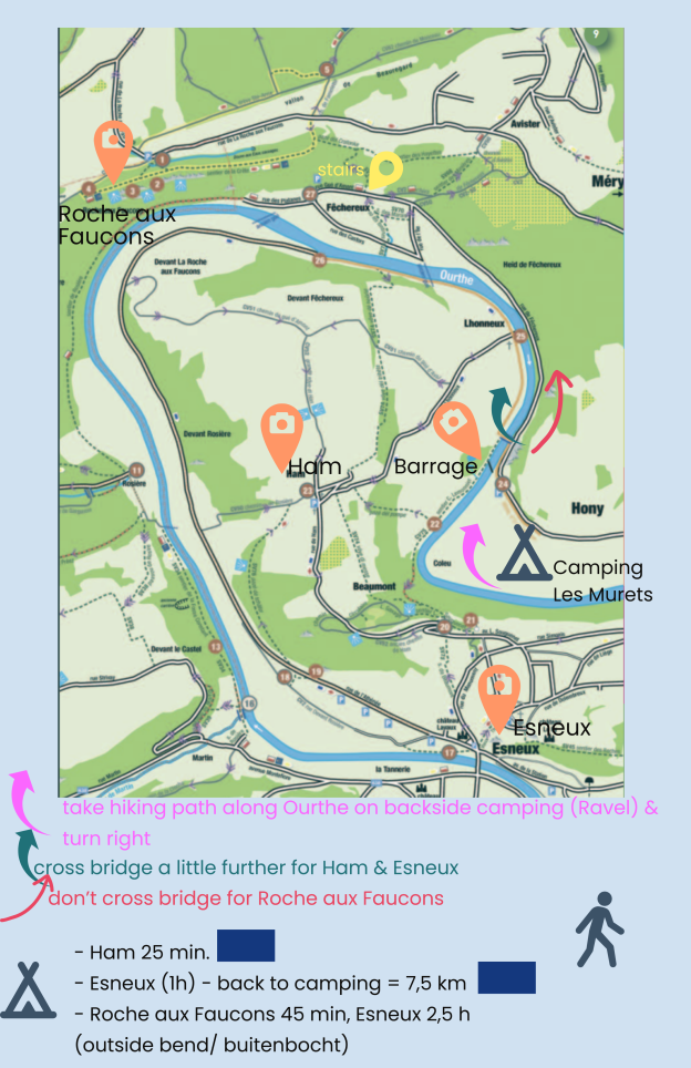
*** RECOMMENDATIONS *** (see map above)
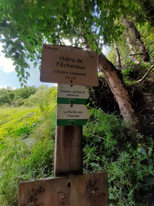
![]() PANORAMA ‘la ROCHE aux FAUCONS’ (altitude 224 m)
PANORAMA ‘la ROCHE aux FAUCONS’ (altitude 224 m)
Going up ± 1h
- Walk to the dam (barrage).
- Keep right (→) (you do not cross the bridge) and ascend via rue de Fèchereux
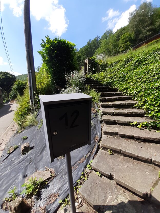
- In front of house no. 12 right up the footpath towards la Roche aux Faucons
Back ± 1h – From the Falcon Rock you can follow ![]() (turn right in the car park). In the village of Hony, turn right at the pharmacy (rue Ferdinand Spineux). 700m later you are at the campsite.
(turn right in the car park). In the village of Hony, turn right at the pharmacy (rue Ferdinand Spineux). 700m later you are at the campsite.
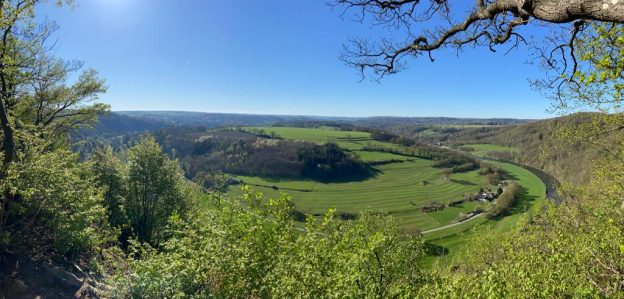
Magnificent view from the Falcon Rock
![]() Esneux & the picturesque hamlet of HAM
Esneux & the picturesque hamlet of HAM
TARPAN-route ‘Boucle de l’Ourthe’ – ± 8km
- Walk to the dam (barrage).
- Cross the bridge (→) and walk 5 km flat to Esneux
 . Here there are nice cafés and restaurants.
 - Via Ham you walk another ± 3 km through woods and hills to the campsite
Ham was listed in 1991 so that its unique architectural appearance is preserved.
Download the hike ![]() ‘Boucle de l’Ourthe’ (8 km) and the hike
‘Boucle de l’Ourthe’ (8 km) and the hike ![]() ‘Promenade des Artistes’.
‘Promenade des Artistes’.
Download the hike ![]() ‘Circuit de la Roche au Faucons’ (12 km). The first sign can be found near the pharmacy in Hony, 700m tot the right from the campsite.
‘Circuit de la Roche au Faucons’ (12 km). The first sign can be found near the pharmacy in Hony, 700m tot the right from the campsite.
Other TARPAN walks in Esneux commune ( folders). Online, you can find the overview of local TARPAN routes here (choose ‘Esneux’ as municipality).
ESNEUX
Mary’s park in Esneux (100 ha) is characterised by a wide variety of tree species, some of which are centuries old. The park also contains several ponds, picnic areas and the Tessenire arboretum. In the ‘Domaine du Rond-Chêne’ there is a more than 30-metre-high sequoia, the thickest tree in Belgium. Its trunk has a circumference of more than seven metres. The tree stands on a plot not open to the public near the castle but is, however, very visible from the public road.
Parking parc du Mary: rue Parc du Mary 22, 4130 Esneux.
TILFF (ESNEUX)
- Ile du Moulin / Les 2 rives


- Boucle de Baory / Brialmont

- Chawresse / Bois des Manants

- De Limoges à Sècheval / Randonnée de la Roche-aux-Faucons

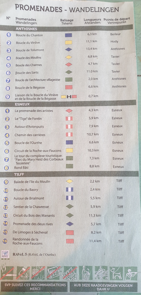
The legend below provides the overview of all Tarpan walks on the hiking map ‘Carte IGN Tarpan Anthisnes-Esneux’ with the 16 hiking routes in the municipality of Tilff-Esneux. The map is on display at reception; it is not for sale on the campsite. You can order it online or buy it at the tourist office in Tilff (Esneux) for 8 euros. Online, you can find the overview of local TARPAN routes here (choose ‘Esneux’ as municipality).
Walking in and around Esneux with the hiking app Komoot – the 20 most beautiful hiking routes around Esneux
*** TIP ***
On foot from STATION LUIK-GUILLEMINS to Camping Les Murets
- 17 km flat, along the Ourthe via the network Node System. At node 22, walk on to the campsite. We are between nodes 22 and 23. Liege-Guillemins is node 1, then 7-6-5-11-13-14-17-21-22. Rest, pizza and a beer earned! Return by direct train in 16 min from Hony station (350m from the campsite) to Liège-Guillemins station.
- or hilly via GR 57 and pilgrimage route Santiago de Compostella ‘Via Mosana’ . This is the section of the Via Mosana from Liège-Guillemins station to Esneux. Camping Les Murets is about 3 kilometres from the GR57 and the Via Mosana. You deviate from this route if you want to go to the campsite near la Roche aux Faucons. You walk to the village of Fêchereux, to the paved road in this village, and turn left there.
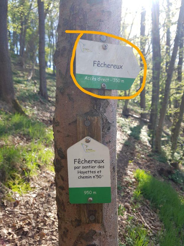
After a while, this road goes along the Ourthe. After about forty-five minutes from the point where you deviate, you arrive at campsite Les Murets, after the first two houses on your right, at the beginning of Hony.
Finished walking in the immediate neighbourhood?
- Then catch the train south at Hony station (350 m from campsite) and spend a day hiking in the area around Comblain-au-Pont, Hamoir, Sy and touristy Durbuy (Barvaux station). No lugging your things & no parking worries!
- Or drive to Sedoz (25km) for the adventurous hike of the Ninglinspo, Belgium’s only mountain river. A walk along the Ninglinspo is a unique experience and thousands of people visit this area every year. It is therefore always crowded. Afterwards, you return to the tranquillity of your favourite campsite 🙂
- the Hoëgne hike in Jalhay (39 km) a great alternative to the always busy Ninglinspo hike
- to Solwaster (37km – Jalhay) to the valley of the Sawe and the valley of the Statte, with waterfalls. These walks are much less known than the Ninglinspo and the Hoëgne.
- To Belgium’s highest point in the High Fens, in eastern Wallonia: Signal de Botrange at 694m in Waimes (47 km). The Great Round of the High Fens of 8.7 km takes you along characteristic wooden paths built on the moor to discover the beauty of a unique nature reserve!